 | |
| This is not a "tree structure" but a stack of saplings cut by a trail crew in the San Isabel NF. But it could pass for one if you ignore the saw cuts on the butt ends. |
Part 2: "The First Hike"
Part 3: "Flesh and Blood"
Part 4: "Paranormal Bigfoot"
Search YouTube for "Bigfoot tree structures," and you will get dozens of hits with titles like "My Bigfoot Story Ep. 48 - Stick Structures and Other Signs" and "Team Finds Multiple Unexplainable Tree Structures." (Just click here for a bigger sample.)
What is a "tree structure"? The definition is pretty loose. Apparently any two or three or four (usually) smaller-diameter trunks lying against each other in a vaguely tipi-shaped way is a "structure." Some people talk about "stick structures": broken or leaning sticks, particularly if they seemed to be arranged in some non-random way.
There are also "tree breaks," for Bigfoot is often thought to snap trees by brute force as a way of scaring off intruders.
What do tree structures mean? Here is some typical speculation:
As for why Bigfoot might engage in such curious behavior, the theories are several. At first glance, one might assume they have been constructed to offer the beasts a degree of shelter, and particularly so during the cold, winter months. In many cases, however, there does not appear to have been any attempt made to create a canopy or walls. In other words, the structures are open to the environment and all of its attendant harshness. Other theories are more intriguing: it has been speculated that, perhaps, the teepees represent territorial markers, created by Bigfoot creatures to alert others of their kind that they are present in the area. They may also be a warning to man, to stay firmly away – although, of course, the obscure nature of the formations effectively means that very few are of us are likely to understand such a warning, never mind act upon it.Meanwhile, back on Monkey Creek, June 20, 2022, having had our first short walk, I looked at the map and saw that a rough Forest Service road (dashed lines), climbing toward Topaz Mountain, crossed Monkey Creek higher up. Back in the Jeep, Marco and I headed that way.
Aside from some protruding rocks, the road was in good shape. No one else appeared to be up there. We drove down into one drainage (yet another "Beaver Creek") then up and along to where it crossed Monkey Creek.
There we found a small parking lot (probably a former loggers' "landing") and signage for the Nate Stulz Trail, which runs from Lost Park (where we had come in from South Park) up and over the Tarryalls to another trailhead near Tarryall Reservoir.
After investigating the creek, which seemed to lack little brookies, we followed the trail upstream, but ended up losing it, because a creek crossing was obscured by brush.
We went on fifty yards or so on the "wrong" side of the creek, and then I spotted what looked like a road further up — it was an old logging road, full of sapling spruces, and we followed it ten minutes or so until it crossed the creek and intersected the official trail.
 |
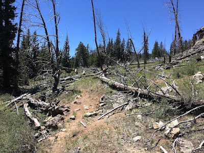
| The trail led up through an old forest fire burn. |
There had been a forest fire up there, probably a lightning strike since we were on a ridge, and I guess-timated that it was more than twenty years in the past. What had been standing dead spruce had rotted at the roots and fallen to the winter winds, mostly all pointing the same direction.
I whistled for Marco and started on up the trail. I could see more open views in the near distance, and it was a great day for a hike in the Tarryalls.
And then something else caught my eye.

No comments:
Post a Comment