Showing posts with label New Mexico. Show all posts

August 30, 2026

Where Are the Jolly Lumberjacks When You Need Them?

  
Video from Colorado Parks and Wildlife. 

A
log jam on the Arkansas River -- probably the first time I have heard of one of those -- is frustrating boaters in the Brown's Canyon section:

The blockage, below Hecla Junction and downstream of the Seidel’s Suckhole rapid in lower Browns Canyon, stretches for 100 yards, and anyone using the river is required to portage around it. Nobody should try to cross the debris raft or try to remove parts of it, state officials said, as the floating wood is unstable. 

You never know, maybe some of those young guys who throw axes in taverns might equip themselves with caulk boots, buffalo plaid shirts, and peavey poles, and try to clear it. Probably best to leave the job to the spring run-off though.

The source of these logs is not mentioned. No large fires have burned above that spot recently. I am open to suggestions,

Now if you want a real big log jam, try the "Red River Raft." Miles long, many years old.

The raft removal project, initiated by Captain Henry Shreve in the 1830s, opened new territory in Louisiana and East Texas for settlement and agriculture. Its engineering audacity inadvertently reshaped the geology of the Lower Mississippi River watershed.

The "Red River Raft" came to the US government's attention in 1806 when it was blocked the upstream  progress of the Freeman and Custis "Red-River Arkansas" expedition. It was centuries old and nearly a hundred miles long. 

The Louisiana Purchase, more or less (Wikipedia)
This expedition was a less-known parallel to Lewis and Clark's trip up the Missouri River and to the Pacific Ocean, and Zebulon Pike's probe up the Arkansas River.

All three expeditions were devoted to exploring our 1803 Louisiana Purchase from France, which supposedly covered all French land claims in the Mississippi drainage.  

The problem was that Spain claimed some of that territory too. In fact, President Jefferson thought that a frontier war with Spain was a distinct possibility.

The Spanish tried twice to intercept Lewis and Clark on the prairie but were too late both times. As is well-known, they did shadow the Pike expedition along the Arkansas and captured his little group (who probably were in fact spying as well as exploring) in the San Luis Valley of Colorado in February 1807. 

The Freeman-Custis Expedition, the most purely scientific, was an easy snatch for the Spanish. As Dan Flores writes,

The Spaniards had no intention, then, of letting the Americans treat with Comanches and groups like that, and so for their own reasons, the Spaniards were determined to make every effort to block these American expeditions. . . . the Red River of the South was easily accessible to those Spanish troops, and so Spain, in the spring of eighteen-six, began to put together a plan for stopping this Southwestern Expedition. It decided—the Spanish government in Madrid, and in Cuba—decided to, first of all, alert the authorities in New Mexico and in Texas of the impending American expedition. 

Collecting specimens and mapping, the expedition (with Caddo Indian guides) had to pole their boats through streams and swamps to bypass the Great Raft. But then on July 29, 1806, on roughly today's Arkansas-Oklahoma border, they encountered about two hundred Spanish cavalry troopers. Oops.

No blood was shed. The Spanish commander, Capt. Francisco Viana, was firm with them.

He said, my instructions are, you cannot proceed beyond this point. He said, this is as far as the French ever established settlements and posts the Americans had passed an old French post about two days before. And the Spaniards had set up their blockade of the river just about fifty miles upstream of that old French post, and Viana said, this is as far as the French ever proceeded on the Red River, the country above this is ours, and you are going to have to retrograde to American territory. 

Thomas Freeman, the expedition leader, was a civil engineer, not a soldier like Zebulon Pike or Meriwether Lewis, although some American soldiers were present for protection. This was not a military probe of hostile territory. President Jefferson had given Freeman written instructions that if they encountered hostile forces, they should turn around. And so they did.

Flores has several reasons why no one remembers the Freeman-Custis Expedition:

This expedition, blocked by the Spanish army in 1806, simply doesn’t play into the idea of American expansion across the Southwest. Now, it may be, in our own time, as the history of the West becomes more multicultural, that Hispanic-Americans in the Southwest will look upon the outcome of this expedition as sort of one of their victories in blocking American imperialist expansion into the West. But, I think in terms of American national history, this is one of those events that can’t be fitted comfortably into the story of a successful kind of migration of the American people across the continent.

Another thing that makes it an invisible expedition to a certain extent is that the scientific results were relatively meagre, and they were undermined really by how the expedition was reported by the Jefferson administration. The map that resulted from the expedition was a remarkable map, but it didn’t really explore very far into territory that the French hadn’t already explored. So it didn’t provide much in the way of new geographical discoveries.

Peter Custis’s work, on the other hand, I think, had things played out a little differently, might have made the expedition very well known and famous, but the way, in fact, Custis’s work did pan out, it made the expedition even more ill-starred. What happened was that Custis wrote descriptions of more than two hundred and sixty-seven plants and animals that he described on this four-and-a-half-month expedition. It’s a remarkable ecological kind of time machine into what the Red River was like in 1806.

But the the publication was fumbled: you can read more here.

June 09, 2025

When Your Dog Sends You a Message


L
ate in May (a month when I did not blogging, sorry, but I had reasons), my wife and I made a short trip to Taos, New Mexico, to decompress and spend the evenings having dinner with various friends there. 

We had rented an AirBnB that permitted dogs, so Marco the Chesapeake was coming along. 

Like every dog I have known, he recognizes when you are packing, whether for a trip to town or a long trip, and he is right there expecting to come along. Sometimes, yes, sometimes no.

This time, I had left my bag on the bedroom floor while I tossed in last-minute items. I came back to it after doing something else — and there was his Kong toy in the bag

"Don't forget me."

It gave me great pleasure to send him the "You're doing, for sure!" signal, which was to load his crate into the Jeep.  

February 23, 2025

Don't give away secrets so freely : )

Portions of Backcountry Discovery Routes in southern Colorado and northern New Mexico.

This blog post's title quotes a comment on another post on X (formerly Twitter) about the Backcountry Discovery Routes. These run throughout the West, plus part of New England, and are a mixture of off-pavement and two-lane blacktop routes for multi-day motorcycle trips. (Not for big highway cruiser bikes, obviously.)

There is the Continental Divide National Scenic Trail for hikers and backpackers. Last summer, a friend of mine rode a good piece of the Great Divide Mountain Bike Route, which routes riders on back-country trails and gravel roads, for the most part, but with some blacktop routes when necessary. He rode from northern Arizona to Salida, Colorado, with all his gear on the bicycle. Some of the "trails" he photographed in Arizona were more like rock-hopping.

So it seems like GDMBR and the BDR might conceptually overlap, except that parts of the former are probably designated as "no motor vehicles."

I can tell from the maps that the BDR overlaps some designated Colorado Scenic Byways, which also are mostly two-lane blacktop. The BDR maps have more information on food, lodging, etc.

The user who posted on X responded to the comment quoted above with "Most don’t leave their basement we’re good."

October 02, 2024

Pot Creek: The Ruins of the Interpretation of the Ruins

Back in 2017, a columnist for the Taos News wrote about Pot Creek, the area's "best-kept secret archaeological site." It was not until earlier this summer, a mere seven years later, that I thought to check that out.

I had seen the entrance signage many times,  but I did not know that "For 25 years or so this little gem has been closed to visitors. But while still officially closed, the Forest Service turns a blind eye to eager curiosity seekers." (Yes, grammarians, that is a "dangling modifier." Evidently no one edited "Backpackerbill.") 

This is a site that was re-discovered by Luria Vickery in the early 1970s while doing work on an advanced degree in archaeology. In 1992 a Forest Service team, under the cultural guidance of a Picuris Pueblo representative Richard Mermejo, and a representative of Taos Pueblo, spent a considerable sum shoring up the remains of an ancient Pot Creek pueblo dwelling and kiva, making it available to the public.

It included a dozen interpretive signs spaced out along a hardened pathway with benches for contemplation at rest stops. The signs and benches are still there in surprisingly good condition after 25 years of neglect.

Back then, the Forest Service also developed a paved parking area with rest rooms, which sadly deteriorated beyond repair. A docent lived on the site at the time, providing information and guided tours. Of course, there is none today. Since then, the site has gone into serious neglect and has been closed for the past few decades.

Aggressive signage that the locals ignore.

Part of the problem may be a joint ownership of the site between the US Forest Service and Southern Methodist University, whose Fort Burgwin satellite site is nearby. 

I pulled in there, seeing one other vehicle (never met its occupant) and a barbed wire fence. It was easy to find the path along the fence that led to a break and to step through.

There was a map of the interpretive trail. It felt like something left by the Ancient Ones, although I could read it.

Marco the dog and I followed the trail. We walked through today's piñon-juniper forest through land that at one time was cornfield and dwellings and kivas. Few if any trees, most likely.

There are other Ancestral Puebloan sites like that in the hills south of Taos along NM 518. I was once walking one of the many "social trails" and came across a complete kiva, boarded over, with a very rickety modern ladder leading down into it.

A similar boarded-up kiva at Pot Creek itself.
I thought for a moment about exploring that other kiva, but then considered that if the ladder broke, I would be down there alone, and expecting a Chesapeake Bay retriever to punch 911 into a cell phone is expecting a bit too much.

But all was not static at Pot Creek. Forestry crews had been on-site quite recently, thinning the timber. Piles of juniper logs were everywhere — great firewood for somebody. Here they are paired with signage. Yeah, the "magic of juniper" would be in my wood-burner. Unfortunately, it is more than a hundred miles away

So clearly there is no money in the public-education archaeology budget, but there is money in the wildland fire-mitigation budget, and someone decided to spend some of that at Pot Creek, perhaps as a gesture toward preserving the site.

Finally the trail led to this parking lot, with vegetation slowly cracking the asphalt. Room for fifty or more vehicles, but none on that day. And the handrails were overdue to be repainted. 

The Ancestral Pueblo people who lived at Pot Creek abandoned it centuries ago. Maybe they were too vulnerable to incursions by mounted Comanche raiders and moved to either Taos or Picuris pueblos. 

Perhaps someday, someone will re-interpret the interpretive site: "This flat area, now thickly covered with pine duff, was once a gathering place for pilgrims who came to visit these more ancient sites. Excavations have revealed a layer of pebbles mixed with bitumen, possibly a ceremonial site or a site of athletic contests."

Or maybe the clash of bureaucracies can be resolved.

September 08, 2024

Our Southern Rockies Desert is Amazingly Young

The northern border of the Chihuahan Desert in is (very roughly) US 50 and the Arkansas River in southeastern Colorado. It forms an "embayment" in eastern Frémont County, and otherwise it laps against the various ranges of the Southern Rockies, extending southward into the Mexican state for which it is named.

One of its iconic critters will be celebrated September 27–28 in and around La Junta, Colorado, during the annual Tarantula Fest.

In this video from New Mexico State University,

Intrepid host Kevin Von Finger guides you through the fascinating arid environment of the Chihuahuan Desert, our North American Outback. Visit ancient caves with revealing clues that indicate this desert is surprisingly young. See gigantic skeletons from animals that roamed the area in the last Ice Age-mammoths, giant sloths, and prehistoric camels. Learn about the phenomenal changes that this land has seen since the beginning of earth. Our North American Outback provides a unique journey to North America's largest desert.
And climate change? Honey, you ain't seeing nothing like the High Plains Altithermal.

January 02, 2024

The Man Who Is Buying the Colorado Prairie

Click to enlarge (Source: Bloomberg)
Stefan Soloviev is only the 26th largest landowner in America, so he has a way to go to catch up with John Malone or Ted Turner.

Stefan Soloviev (Business Insider)

I do remember when he bought the grandly named Colorado Pacific Railroad, all 122 miles of it, in 2018. But there was more to come, much more. The New York businessman, still in his 20s, started buying land. Then he went to see it, in this case, in Prowers County, southeast Colorado, which includes the town of Lamar.

“It was 6 miles off the paved road and I’m driving and everything looks the same and I’m driving and driving and I finally get to the property and I’m like, ‘Oh, my God, I’m in the middle of nowhere.’ And I had a bit of a panic attack,” he says during a wandering interview with The Colorado Sun. “I’ll never forget that first time out here. It’s gotten easier. You adjust. You adjust to your surroundings. You start to become part of the community.”

He also has a pretty good spread in east-central New Mexico, as you will see if you explore this Bloomberg graphic article on America's top one hundred landowners.

Land: they ain't making any more of it. 

Soloviev, meanwhile, has big plans:

So the pitch looks like this: Rent his farmland at market rates. Grow your own grains. Truck them to Soloviev’s grain elevator close to the Colorado-Kansas border. Then ship the grain on his new Colorado Pacific Railroad to Pueblo to access Union Pacific’s national rail network. Soloviev says eventually he wants to grow into the international exporting business with cargo ships that can move Colorado grain “as far as I can take it.”

November 29, 2023

Life, Death, and Coffee in Clayton, New Mexico


No one is ever on the sidewalks in Clayton, New Mexico. Its population has trended down since 1960, and if you want to visit a store or other business, you can generally park right in front. The longest walk in town is probably from the farthest truckers' diesel pumps to the convenience store entrance at the Love's fuel stop.

I once tried to walk around downtown (was staying at the restored Eklund Hotel) and came the nearest ever to being forcibly disincarnated by a passing pickup truck, even through I was crossing with the light. I felt the backwash of Death's wings, I can tell you that. 

Maybe the driver was so unused to seeing a person on crossing the street that he assumed I was an incorporeal ghost. Or he was drunk.

So when I make my regular US 87 coffee stop at Crossroads Coffee (a.k.a. Mock's Crossroads Coffee Mill) I park in front or in the little gravel lot alongside, or on rare occasions I use the drive-up window.

There's no need to walk.

July 10, 2023

Colorado Is Now Out of Drought, But New Mexico Is Not

Click to embiggen.
This graphic displays moisture changes in Colorado over the last 90 days. As you can see, the Eastern Slope and High Plains have been wet. Nearly 11 inches (28 cm) have fallen at my house, and other places have more. While in some climates that counts as "somewhat damp," for us it is "Oh my gawd when will it stop?"

 The plains in particular have had tons of hail, which threaten the wheat harvest.

"Heavy rains and severe thunderstorms continue in the Southern Plains where producers are watching forquality impacts. In Colorado, Wyoming and South Dakota, producers are hoping for dryer and/or warmer weather ahead of harvest." (US Wheat Associates harvest report, July 7, 2023).

On the other hand, it is starting to look like a good summer wildlflower season, although spring was not so good.


A quarter of New Mexico is "abnormally dry," while the southeastern quadrant is in either "moderate" or "severe" drought.

If you find this information endlessly fascinating, visit the .gov "Drought Portal." Your tax dollars at work.


September 18, 2022

Marco Gets a Poem at the Taos Farmers Market


The Saturday farmers market in Taos, New Mexico, is a rarity: sellers of food outnumber the sellers of homemade soap, crocheted potholders, and other non-edible items. Especially now, when local tomatoes, corn, pears, etc. are flooding in. 

I bought some pears that were small, with brown patches, not pretty enough for a supermarket display—but wow, the fresh pear flavor! 

And you can buy poetry. There are often one or two poets for hire who sit with portable typewriters, ready to produce a poem for any prompt—which is a great way to develop your poetic virtuosity.

 I ordered a poem a few years ago about a long-gone downstairs bar on the plaza after I overheard two guys talking about it. I had my first legal (American) drink down there when I turned 21, while working here. (This is not counting a certain Third World country where I think I had my first drink in a bar at 16.)

Today it was for Marco, the new Chesapeake Bay retriever. I introduced him to itinerant poet Marshall James Kavanaugh, who started tapping the keys. It's one draft only, no capital letteers but one, no revision, don't keep the buyer waiting too long!

a big day
for a big fella
finding the small world of home
extends into a community at large
a place for harvests to grow
for friends to be had
every tail wag of golden splendor
ricochets with raucus energy
such sweet tastes
and alluring smells

to be Marco at the market
is to be a gentle discoverer
sailing ancient seas
tapping the toes to paths leading
in every direction

like a dream, there are things
to chase that give themselves
up to our impressions

a companion that grows
like this scene of abundance
he is the explorer
that gives curiousity its name.

Your dog deserves a poem too.

September 17, 2022

"Right to Wade" Advances in New Mexico and Colorado

Fly-fishing in Colorado (Colorado Parks & Wildife photo)

I am writing this from northern New Mexico, where there are some trout streams — and the usual controveries over landowners blocking access.

Earlier this month, the New Mexico Supreme Court issued an important decision:

The court’s long-awaited opinion further clarifies its March 1 oral decision, which overturned a State Game Commission rule that allowed private landowners to exclude the public from streams flowing through their property. This unanimous decision, as many anglers interpreted it, effectively re-established the public’s constitutional right to wade and fish in these streams.
The court explained that the public’s right to fish and recreate in New Mexico streams has always superseded a private landowner’s right to exclude the public from privately owned streambeds. The justices stressed that as long as the public does not trespass on privately owned lands to access public water, they have every right to walk on and float over these streambeds in order to fish.

Meanwhile, the New York Times has noticed the access war on Colorado rivers, with a case sparked by angler Roger Hill, 81, who enjoys fishing the Arkansas but has encountered viscious opposition by riverside landowners.

The exploding popularity of the outdoors, fueled in part by the limits of the pandemic, has brought a new term to what has long been an etiquette-obsessed sport: combat fishing.

“I tried to take my son fishing last spring,” said Flora Jewell-Stern of Denver, a member of the first all-female team to win the state’s prestigious Superfly tournament. “There was nowhere to park for three miles. And it was a Wednesday.”

For advocates of public access, an upside to the conflict has been the formation of an increasingly assertive alliance of rafters, hunters, kayakers and other river users. Many see themselves as defending more than just pastimes.

Colorado does not have a definitive high-court opinion, but one will be coming. At issue, whether a river or stream is "navigable," which means accessible.

“We’re a total outlier,” said Mark Squillace, an environmental law professor at the University of Colorado who is representing Mr. Hill. “Standing in the bed of the river is something the U.S. Supreme Court has explicitly guaranteed, and the idea that Colorado would try to deny those rights, which are enjoyed by the citizens of every other state, is pretty shocking.”

Mr. Hill would like the state to clarify its position in the face of his historical evidence, which mainly consists of newspaper clippings from the 1870s demonstrating that the Arkansas was at the time flooded with timber used for railroad construction.

“There’s no doubt it’s navigable,” he said.

The attorney general has argued that Mr. Hill lacks standing; the State Supreme Court is reviewing the case, potentially paving the way for a trial this fall.

August 27, 2022

Where Is the Mountain Lion in This Photo?

Photo: US Fish and Wildlife Service
 

The elk triggered a scout camera at Rio Mora National Wildlife Refuge in New Mexico. But someone else was watching. Can you see the mountain lion? 

It helps to enlarge the photo.

May 02, 2022

What the Spring Breezes Bring Us

Some National Weather service video from Saturday afternoon, April 30, 2022. As three fires burn west of Las Vegas, New Mexico, a dust storm rolls south from Baca County, Colorado, the heart of the 1930s Dust Bowl, and continues across the Oklahoma Panhandle.

February 21, 2022

New Mexico Newspaper Noir


Clickbait? That is nothing new. Watch Kirk Douglas as obnoxious, erratic, but talented reporter Chuck Tatum in the 1951 noir film Ace in the Hole (directed and co-written by Billy Wilder) and set somewhere west of Gallup, New Mexico.

Chuck Tatum's brilliant plan is to extend a mine-rescue story over multiple days to benefit his new Albuquerque employer, even though it means putting the victim at greater risk.

In this case, a pot hunter (still an honorable job in 1951) is trapped by a cave-in. Apparently, when the Ancestral Puebloans were not hauling pine logs for many many miles to build kiva roofs, they were hauling them to timber hand-dug adits where they buried their dead. Who knew? 

The trapped man, who with his family runs a little diner and curio shop on Route 66, tell Tatum that the ancient pot he just found is worth "fifty bucks." (That's $553.44 today, according to the gummint, if you believe them.)

So instead of the private investigator in the dusty office, we have strong-jawed but amoral Kirk Douglas at a dusty movie-set ciff dwelling, the location of which you can find on Google Earth, etc. at  35°23'53.6"N, 109°01'12.0"W.

Jan Sterling plays the equally amoral peroxide blonde wife of the trapped man, who wants nothing more than to get out and head for the bright lights. She gets lines like "I don't go to church. Kneeling bags my nylons."

Iron Eyes Cody, that American Indian film star from Sicily, makes a brief appearance as a newspaper copy boy.

The movie's trivia page at the Internet Movie Database includes this observation:

This film's utter and unrelenting cynicism so repulsed 1951 movie audiences that it lost Paramount a fortune. Writer/director Billy Wilder later admitted that it had a negative impact on his career...while also citing it as one of the best films he ever made.

Wilder had other big successes like Sunset Boulevard and Some Like It Hot, and given that this was the era of Film Noir, maybe audiences just could not swallow a "noir" approach in an non-urban setting.

As something of a film-location nerd, I was impressed that it was actually made in New Mexico, years before New Mexico's state government got into the film-and-TV promotion business.

October 19, 2021

Everybody Thinks Something about the Resort-Town Housing Crisis

Victor, Colorado, had lots of houses when it was a mining town.
Not so many second-home owners back in those days.

Mountain and resort-town housing — the lack of it — is lighting up Rocky Mountain news sites. Town councils are suddenly turning nasty and seeing seasonal homeowners as the obstacle to year-around workers finding a place to live. Or they start cracking down on short-term rentals. Breckenridge, for example:

Breckenridge, with its ski slopes reaching into the middle of town, is a short-term rental haven. The town has 3,945 privately owned homes and condos that vacationers can rent. The town council, in an effort town leaders described as a way “to protect our quality of life and the fabric of our community” and “fiercely protect the character of Breckenridge,” on Tuesday unanimously approved a 2,200-property cap on so-called exempt short-term rentals in the town. Those are the homes that are not part of a larger hotel-like complex that offers a staffed front-desk and security. . . . The vacation-rental strategies deployed in Aspen, Breckenridge, Chaffee County, Crested Butte, Eagle County, Grand County, Steamboat Springs, Telluride and  Summit County all differ, but one thing is clear: The largely unfettered growth of short-term rentals in Colorado’s high country is coming to an end.

Hotel owners must like the idea of capping short-term rentals a lot.

I feel like I have been on all sides of this issue. I have sought Colorado small-town housing in situations of "Take it now, it's the best you can get." 

Then not along ago, I was walking down a street in Taos, New Mexico, and recognized a little apartment where as a twenty-something I had a short-term relationship with a woman who lived there. I don't remember how we met or how she supported herself. What I thought instead was, "I bet that's an AirBnB rental now."

Yet my wife and I were staying in an AirBnB rental nearby ourselves! We like to be able to cook our own meals, for one thing. Sneaking an electric hot plate into a motel room gets old.

On the other side, we were short-term rental landlords from 2002 to 2020, when our county briefly shut down all short-term rentals because of the pandemic — just when we had decided to change from a do-it-yourself approach to listing with VRBO

When we switched our "guest cabin" from long-term to short-term, we knew we were taking a rental property off the market in an area where rentals are very difficult to find. But there were advantages from our end:

  • Short-term renters do less damage. They don't leave junk cars on the property or mysteriously acquire extra dogs.
  • The cabin's well is a little unreliable. It is easy to call someone to haul water for the cistern for short-term guests, but that would be really expensive to do for long-term renters.
  • The short-term approach let us block out times for family and friends and for our own occasional travel. 

Financially, we probably did not do as well, since the business was highly seasonal, but we paid the taxes and insurance and got the income-tax write-off for rental properties. But we could have rented it to that newly hired schoolteacher that you read about in all the news stories, the one who ends up turning down the job because s/he can't find a place to live.

There’s no affordable housing in Mancos. Zero rental units. Nearly no houses on the market. The town’s school district struggles to hire teachers because they can’t find a place to live. It’s the same story with the town government, the hospital and the nursing home.

Maybe if we get the well-situation worked out, we can do that. And new flooring downstairs. Et cetera.

Small towns that want to build municipally funded housing find problems too. Some have to go with geology, others with the construction economy.

Pagosa Springs, for example, has earmarked land for affordable housing but struggled to get the attention of developers. After receiving zero responses to a request to build a dozen units last spring, the town this fall expanded the development to include up to 64 units on three plots of land, offered at little to no cost. It got three responses. 

“These guys are making good money right now building custom homes,” Pagosa Springs councilmember Mat deGraaf said of developers. “If you’ve ever worked in the trades, you make hay when the sun shines. And right now the sun is shining so I don’t fault them.”

So even when towns want to spend money on housing, there can be obstacles.

I don't think it does much good to beat up on that out-of-state person who owns a "Christmas house" in Blue River or Telluride though. They can rent short-term (given a local property manager), but they are not going to rent to that cop or schoolteacher because they themselves want to use the house or condo at certain times. How do you get around that problem? (And don't suggest expropriating these "exploiters"' houses at gunpoint—not likely to happen.)

Playing the "quality of life" card and capping short-term rentals, however, might be politically feasible, but there will lots of pushbacks from people who depend on that income to pay for the "Christmas house." And there is an economic argument.

One short-term rental manager said,

“All the business owners in Breckenridge who rely on visitor spending, they are getting it from my group,” said Carol Kresge, the manager of the sprawling home that was originally built as a B&B but now can be rented short-term by vacationing groups who pay as much as $4,000 a night. . . . “Hearing that short-term rentals are destroying the character of Breckenridge is disturbing and it’s just not true . . . The visitors who visit the lodge are the character of Breckenridge. They come into town and they spend their money at the local restaurants and shops. A cap on short-term rentals is a broad brush approach designed to solve a problem that hasn’t been well defined.”

The economic argument leads to a larger question: Can outdoor recreation "save" small towns in pretty places. Some economists say no. But that is a separate blog post.

November 13, 2020

3D Adobe Printing Could Be an Option for Southwestern Builders


Me in my good black shirt at a job site.

Back when I was a college student, I spent a couple of summers laying adobe bricks in Taos, New Mexico. Under the tutelage of the foreman, Phil Rael, I got to be fairly good at spreading the zoquite [local slang, from Nahuatl] and setting the bricks. 

In the project pictures, the bricks were trucked down from San Luis, Colorado, where they were made in some rehabilitation program for junkies, or something similar. They were top-quality, asphalt stabilized, a little larger than the local homemade variety.

They arrived on an old flatbed truck by two middlemen. I was trying to document this project, and those two were a little camera-shy. Here is one of them, Pat W. I kind of think he dealt in more than one kind of bricks. 

But that is so old-school! Now they are using 3D printers with adobe in the San Luis Valley -- at least in one pilot project. Sweet!

Combining indigenous mud-based building materials with 21st century robotics, California-based Rael San Fratello created the oddly beautiful structures of “Casa Covida,” their “proto-architectures” that connect high- and low-tech traditions. Its name is a nod to both the pandemic and the Spanish word for “cohabitation.” The project recently took a virtual bow in an impressive hour-long event hosted by the Architectural League NY. (The video is online.) The partners, Ronald Rael and Virginia San Fratello, spoke from Antonito, in southern Colorado, and took questions about their work and about “the social agency of design" . . . . .
Pat did not like being photographed.

The creators’ overall goal is to prove that low-cost, low-labor construction is possible, efficient and safe. Think of it as the highest of low-tech. Or down-to-earth high tech.

Using clay, water and wheat straw found onsite, the project aims to“push the boundaries of sustainable and ecological construction.”

It's still an early-stage project, not open to the public. 

What I always liked about adove was the plasticity. You want an arch over there? OK, we'll make one. Was that course of bricks a little out-of-plumb? We'll make it up on the next one. Once it's plastered, no one will know the difference.  

But this new approach goes so much farther! Check out the photos and videos here.

October 23, 2020

The Great Hunt Lasted Only 300 Years?


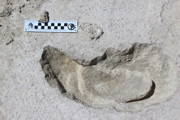
A human following a giant ground sloth stepped in the big beast's tracks.

While someone followed the giant sloth in what is now New Mexico, trying to provoke its attention, someone else (probably spear in hand) was coming in from its blind side:

Meanwhile, another set of human footprints approaches from the opposite direction. These are daintier, with impressions made by raised toes. It seems that while the sloth was flailing, someone else tip-toed up to it from the back. That’s a hunt, [British geographer Matthew] Bennett says. “The strategy was all about stalking to distract and irritate the animal, and get it to turn its back on someone approaching from the blind side.

It was the Great Hunt, and it lasted just three hundred years, so archaeologists propose.

Clovis spear points from the Gault site in Texas. (Center for the Study of the First Americans, Texas A&M University)

At the heart of their argument are "Clovis points," a type of spear point once associated with the first people in the Americas. Now, more scholars are suggesting that the big Clovis points were developed for what the first arrivals found in the way of wildlife — and when those "megafauna," such as giant ground sloths, were all gone, no one bothered making Clovis points anymore.

[Michael Waters, distinguished professor of anthropology and director of the Center for the Study of the First Americans] said that until recently, Clovis was thought to represent the initial group . . . to enter the Americas and that people carrying Clovis weapons and tools spread quickly across the continent and then moved swiftly all the way to the southern tip of South America. However, a short age range for Clovis does not provide sufficient time for people to colonize both North and South America. Furthermore, strong archaeological evidence "amassed over the last few decades shows that people were in the Americas thousands of years before Clovis, but Clovis still remains important because it is so distinctive and widespread across North America," he said.
                                                                                 • • •

"It is intriguing to note that Clovis people first appear 300 years before the demise of the last of the megafauna that once roamed North America during a time of great climatic and environmental change,"  [Waters] said. "The disappearance of Clovis from the archaeological record at 12,750 years ago is coincident with the extinction of mammoth and mastodon, the last of the megafauna. Perhaps Clovis weaponry was developed to hunt the last of these large beasts."

We could say then that "Clovis" is a technology — materials and techniques to produce certain tools — not a "people." Many peoples used Clovis technology, until they abandoned it.

There is a story there we will never know, when the young hunters stood with their spears carrying big points and realized that the really big beasts were gone —although they might have kept them handy for short-faced bears and such.

September 21, 2020

Ghost Birds in the Sky

Nick Vinciguerra collecting dead
Violet-green swallows in Velarde, NM.
(American Birding Assn.)


The unusually strong storm that swept through the southern Rockies and Plains the second week of September pushed " a spectacular array of fall migrants to Albuquerque," as one biologist noted. 

Smoke from West Coast forest fires may also have forced some southbound birds further east as well.

The sad part is that many died — not so much from the smoke as from hunger, one New Mexico researcher, doctoral student Jenna McCullough writes for the American Birding Association website.

Sudden and dramatic unavailability of food caused by a historic and drastic cold snap is, I believe, a more parsimonious explanation than a widespread, smoke induced, mass mortality event. While we do not have data on how fast smoke inhalation would kill birds hundreds of miles away from the fires themselves, what we do have are data from the 258 Violet-green Swallows that Nick and I collected in Velarde this week. . . . .

If a lack of food contributed to the mortality event, birds would have less fat and no protection against hypothermia. Indeed, of the hundreds of birds we assessed, none had fat stores on their bodies. Furthermore, Though we have yet to perform any toxicology analyses or inspect their lungs for signs of smoke inhalation, I think it is safe to say that these birds were starved and succumbed to hypothermia. When USFWS autopsies of other birds are reported in the coming weeks or months, we suspect they will reveal a similar cause of death.

Cold and snow mean no flying insects, which is bad news for swallows and other insectivores.

Here in southern Colorado, I found one Lesser Goldfinch dead in the driveway, uneaten, during that brief cold weather. Considering it was only five seconds' flight from a sunflower seed feeder, it should not have been hungry. But M. and I both were briefly sick that week, which I blamed on the sudden shift from about 94° F to °27 F (34°C to -3° C). Maybe something hit the little goldfinch too.

March 02, 2020

Please Don't Put Oshá on my Cookies

Biscochitos, official state cookie of New Mexico.
This post starts with foragers, but be patient, the Southern Rockies part is coming.

First, from Vice magazine, a piece on rural wild-food foragers in England, which includes this observation:

The pair's foraging ethos sits between the Bear Grylls-style of wild food ("forcing yourself to eat something that tastes horrible") and the "hipsterized" trend to add a foraged element as a garnish, rather than incorporating it into the dish itself. 

So then my wife is reading New Mexico Magazine, and naturally she is drawn to an article about forager-restauranteurs Johnny Ortiz and Afton Love, who operate a tiny restaurant called Shed:
Donning their muddy boots and with recyclable tote bags in hand, they probe the landscape for the edible plant life that a majority of Westerners have long been estranged from, owing to the rise of food monocultures. Ortiz’s food philosophy revolves around foraging and thus maintaining wild plant and animal ecosystems, as well as farming and raising animals, plus digging clay to make much of the ceramic ware in which his meals are served. Shed’s dinners, which consist of a prix fixe menu of 12 small plates, are but the “fruiting body” of an entire ecology.
And, wouldn't you know,
The dishes demonstrate the metaphor: a wafer-thin whole wheat bizcochito [sic] seasoned with fennel, covering a ponderosa pine bark ice cream, sprinkled with piñons shelled in a tortilla press and served in a black micaceous clay bowl made from earth he harvested at a “Taos Pueblo spot where my ancestors would’ve dug from.” There’s osha sprinkled on top.
Oshá, a root, is definitely medicinal — I went through several bottles of the tincture while fighting a virus with a lot of bronchial congestion earlier this winter.

Sprinkling it on a biscochito (essentially a sugar cookie), however, to me is like sprinkling turpentine on vanilla pudding. The taste is not exactly dessert-alicious. Maybe it is "hipsterized." I admit to not having tried it.

November 28, 2019

What Would a Mountain Lion Eat for Thanksgiving?

A wintry view of the riparian area in or near Santa Ana Pueblo,
photographed from Amtrak's Southwest Chief on November 20th.
Brokenleg (Pueblo of Santa Ana DNR)
Deer, you say? That might be a good answer, insofar as a common formula is that an adult must eat a deer-size animal every week to ten days. But down on the Rio Grande north of Albuquerque, researchers at the Pueblo of Santa Ana Department of Natural Resources collared and tracked one male who specialized in badgers.

And here I thought badgers were difficult game for any predator, given their ferocity and ability to dig in.

The lion they called Brokenleg (because of a visible old fractured that had healed and calcified) was monitored for 15 months. Here is what he killed for food:

He was no cripple, as you can see: he took down 17 elk as well.
Brokenleg was one of six lions that the pueblo's Department of Natural Resources collared and tracked. On their Facebook page, they wrote,
We recently posted a graph of Brokenleg's kills that generated a lot of great questions and responses. This graph might do the same and is intended to show the varied diet of 5 lions (3 males and 2 females) that we GPS-collared and followed over variable time spans. The 3 males (months collared in parenthesis) are Big Tom (6), Brokenleg (17), and Lefty (15). The 2 females are Notch (12) and Little Girl (16). We documented 155 kills across 20 species, which are color-coded for individual lions. While Brokenleg's dataset is mostly complete, there are gaps in the other lion datasets because we did not have permission to enter onto some lands to verify kills. Despite not having a complete dataset for all lion kills, the graph clearly illustrates the varied diet of the 5 individual lions. Furthermore, we believe that Big Tom and Notch probably killed at least 15 more feral horses based on kill locations and amount of time at kill site, but because we didn't have permission to verify the kills, we can't confirm this. This is an ongoing project, so we expect we will add some species to the list in the future. (October 14, 2019)
The pueblo controls 73,000 acres, and I have always been told that a lion in the Rockies hunts  territory of 70–100 square miles (640 ac. per square mile). But since mountain lions do not care about human boundaries, obviously a number of them hunt partly on and partly off the pueblo lands. And it is risky to be a badger, a coyote, or a feral horse along the Rio Grande.

October 13, 2019

How Much Heat Is in that Firewood?

Split into six or eight or ten pieces, each round might last a mid-winter day.
A big (by foothills standards) ponderosa pine blew down several years ago, breaking into two with the top section hung up in some big one-seed juniper trees. I spent a lot of time last winter freeing and getting it onto the ground without killing myself, then cut it into rounds, rolled them down a little hill, split them, and moved them to the house.

In process, I ended up with a lot of juniper too, most of which has been drying through the summer, and I am moving it now. That is a one-seed juniper in the background.

Meanwhile, the butt section of the pine tree, which had been soaked by snow, is now dry, so I finished cutting it up today. (That small chunk next to the saw is from another tree.)

Intuitively, I thought the juniper offered more value as fuel, but it does not come in convenient pieces like pine.

But pine surrenders gracefully to the saw — juniper wants to hurt you. If it can't pinch the chain, its rigid twigs will rip your shirt.

Back in 1913, the eight-year-old US Forest Service was answering that question. "The object of the investigation is to determine the heating values of the woods commonly used for fuel in New Mexico and Arizona, including about 10 different species."

They compared them to coal, since many people burned coal for home-heating back then, and also to "Bakersfield crude oil."

The tests were conducted using a "bomb calorimeter." I would like to own one of those just for the name. ("Professor Murcheson will now demonstrate the bomb calorimeter.")

The big winners were alligator juniper and the bark (not the wood) of Douglas fir, both of them delivering more than 10,000 BTUs per pound, or 76 percent as much per pound as Cerrillos anthracite coal. (The area around Cerrillos and Madrid, N.M., used to produce a lot of coal.)

One-seed juniper was almost as good, 9,900 BTUs/lb., equivalent to 75 percent of Cerrillos anthracite.

Ponderosa pine sapwood produced 8,856 BTUs/lb., while the bark produced 9,275.

Aspen (quakies), incidentally, came in at 8,555. They did not measure Gambel oak, but another source placed it almost as high as the one-seed juniper, which fits what I feel standing next to the stove. Piñon pine, 8,629. Some people would that it burns hotter than ponderosa, which I always thought was true. At least one other site supports me.

Another site calculates heat values in million BTUs per cord, a cord being a tightly stacked pile of wood measuring 4 x 4 x 8 feet. (The method of measurement is not specified.)

Here we see ponderosa pine at 21.7 million BTUs/cord; cottonwood, 16.8; aspen, 18; Douglas fir, 26.5; white fir, 21.1— and they don't measure Gambel oak, one-seed juniper, or Rocky Mountain juniper.

What this means, in the end, is that I will pick up any piece of juniper that is as big around as my wrist.